Many people who like saying “Let it snow, let it snow,” look like they are about to get their wish.
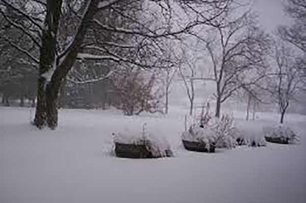
A significant winter storm expected to move into central North Carolina this weekend could bring snow, ice and dangerous travel conditions across the Piedmont Triad, prompting airport officials and emergency planners to urge residents to prepare now and think twice before heading out.
Forecasters are watching a system expected to arrive and intensify Saturday, with snow, sleet and freezing rain possible through Sunday. Temperatures are expected to drop below freezing, raising concerns about icy roads, bridges and power outages.
At Piedmont Triad International Airport, officials say the airport will remain open throughout the storm – but that doesn’t mean flights will be running normally.
Passengers scheduled to depart from PTI are being urged to call their airline before leaving home to confirm whether their flight is operating.
“The airport will remain open throughout this severe weather event,” said Kevin Baker, the Airport Authority’s executive director. “However, airlines may cancel flights because of the storm’s system-wide impacts.”
PTI snow crews will be on duty around the clock to keep runways, taxiways and airport roads operational.
Even so, travelers should expect changes inside and outside the terminal if conditions worsen.
If weather conditions deteriorate significantly, access to the upper departures and ticketing curbside may be closed, with all traffic routed to the lower arrivals level, which offers better protection from the elements. The top level of the parking deck may also close, and airport officials advise all passengers to enter the deck from the lower level if parking is needed.
Airport roadways will be maintained continuously, but officials emphasize that drivers should use caution both at PTI and on the roads leading to and from the airport.
Beyond the airport, the storm could disrupt daily life across Greensboro, High Point and Winston-Salem: The National Weather Service has warned that accumulating snow and ice could make travel hazardous, particularly overnight and during early morning hours.
Bridges and elevated roadways are expected to ice first.
Local governments and school districts haven’t yet announced closures, but residents should be prepared for delayed openings, early dismissals or full closures if conditions worsen. Guilford County offices, libraries and parks may also adjust hours depending on the severity of the storm.
Utility crews are also preparing for the possibility of outages if ice builds up on trees and power lines. Residents are encouraged to charge devices, secure flashlights and avoid unnecessary travel during the height of the storm.
Officials continue to stress that forecasts may change as the system develops, but the message remains consistent: check ahead, slow down and stay home if you can.
Travelers should monitor airline alerts, airport updates and National Weather Service forecasts closely as the weekend approaches.

————-
Storm… Shmorm! I became a grandfather last night!
I guess I’m officially an Old Fart, but my heart is brimming with joy.
“Life is sweet” – my Mamgu’s last words. And it is.
God Bless to you all, and may you each experience the happiness we are enjoying right now.
Congratulations Austin!!!! I’ve been there 4 times now and it never gets old. Always an awesome feeling in my heart ❤️. Spoil them rotten then send them home. Peace in your heart my friend.
* * *
Thanks, Rebel!
Welcome to the club, gramps! Care to disclose your family’s nickname? (hint, I am not disclosing mine).
* * *
We don’t have a nickname as a family Miller, but as a boy I had intense copper red hair and was called “Cocheen” (spelling?) which is the Welsh word for a redhead.
I had blonde hair, but I was called “dickhead”.
a redhead female ?
No, it just means someone with red hair, especially deep lustrous red (which I was… before I began going grey).
Before they take credit again for their forecast, News2 Weather has changed their forecast up to 3 times per day each day this week! Don`t let them tell you they got it right again. Originally, we were supposed to get an ice storm with maybe half an inch of ice. Then they forecast 4-5″ of snow after rain Friday with some sleet and freezing rain Sunday. Then they stated it would be mainly snow and we could get up to 8-9″ but it would still rain Friday, heavily. Yesterday, they took the rain out completely, reduced the snow to 1-3″, and up to 2″ of ice. Guys, most of us have lived here long enough to see these Winter storms from the South, with an Arctic High sinking to the Southeast from the North and creating the damming effect against the mountains. It is a classic set-up. A coastal storm will be developed from this as well. The scenario for this NEARLY EVERY TIME would be 5-7 (+)” if snow, followed by 1″ of ice. Is that really so difficult to predict, based on not only the fancy models but also the history of storms in this area? The really fitting thing about this Southern storm is the name—is there any more Southern name than Fern except maybe Bubba?
this ‘partly cloudy’ day didn’t get my laundry line dry. i have ice skates & cross country skis ready
Nobody really knows right now. There is a storm; but who knows where, when, what, or how.
Just visit your local supermarket to see all the empty shelves. This goes to prove that 80% of Americans live paycheck-to-paycheck. This is real ugly. Who can fix that? Anyone?
i saw people loading up on bread, butt wipes & beer. what kind of sandwich does that make ?
Primoral needs: beer and cigarettes.