There’s an old saying: “Georgia drivers, no survivors.”
Greensboro drivers aren’t quite that bad but the city certainly has some terrible drivers who frequently create dangerous conditions. Many Greensboro drivers don’t know that there is a lever on their steering wheel that alerts others of their intention to turn; a lot don’t know that it’s not a great idea to crank up the high beams at night and blind the drivers coming at them; and many have no idea what to do when two cars arrive simultaneously at a four-way stop. If three Greensboro drivers ever arrived at a four-way stop simultaneously, they would all have to turn off their cars, get out and discuss it for a while and perhaps draw straws to see who should go through the intersection first.
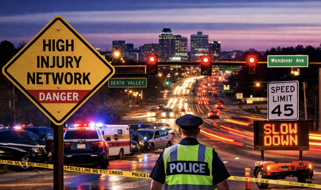
And there are a lot of other problems in the city when it comes to driving and traffic safety as well. Like, just to take one, the insane traffic flow at the intersections of Cornwallis Drive, Battleground and Lawndale, not to mention Death Valley, which, after all, has earned the name “Death Valley.”
And there sure do seem to be a lot of people who get hit in Greensboro trying to cross the street.
It’s obvious: Greensboro has a traffic safety problem. The good news is that city officials have been studying the situation intently and, according to a newly released draft plan, it’s not spread evenly across the city.
Instead, it’s concentrated on a relatively small number of roads that local drivers use every day.
The Greensboro Urban Area Metropolitan Planning Organization has just released its draft Comprehensive Transportation Safety Action Plan – a sweeping document built on years of crash data, public input and in-depth analysis of traffic and accidents in the city.
The goal is highly ambitious: Cut traffic deaths and serious injuries in half by 2035 and eventually get to zero.
And buried inside the 100-plus page report is a finding that helps explain where the city will likely focus its efforts going forward.
According to the plan, 95 percent of fatal and serious injury crashes occur on just 6.9 percent of the region’s roadways.
That small portion of the system is known as the “High Injury Network,” and it includes some of Greensboro’s most heavily traveled corridors — Wendover Avenue, Gate City Boulevard, Market Street, Elm-Eugene Street and US 29 among them.
In other words, the problem isn’t everywhere. It’s concentrated.
The data that led to the plan is difficult to ignore. Between 2017 and 2023, 311 people were killed in crashes across the MPO area, and another 425 were seriously injured. That averages out to more than 50 deaths a year and over 70 serious injuries annually.
Greensboro’s fatality rate – roughly 14.7 deaths per 100,000 residents – is higher than several comparable North Carolina cities, including Raleigh and Durham.
And, while most crashes involve vehicles, the most severe outcomes often don’t.
Pedestrians account for just 1.5 percent of crashes but 26 percent of fatalities, while bicyclists make up only 0.3 percent of crashes but 1.6 percent of deaths.
That imbalance is one of the driving forces of the plan – and part of the reason the plan places such a heavy emphasis on sidewalks, bike lanes and safer crossings.
Still, if there’s one factor that rises above all the others, it’s speed.
The report identifies speeding as the single most significant contributor to fatal and serious injury crashes. In some areas, the numbers are striking. On portions of U.S. 70, data shows many drivers routinely travel at 125 percent to 150 percent of the posted speed limit.
And when speed goes up, survival rates go down.
According to the plan, a pedestrian struck by a vehicle moving at 20 miles per hour has about a 95 percent chance of survival. At 40 miles per hour, that chance drops to around 15 percent.
Interestingly, the report doesn’t frame speeding as simply a driver behavior issue. It points to road design as a major factor – wide lanes, long straight corridors and infrastructure that encourages higher speeds whether posted limits reflect that or not.
That shift in thinking is central to the plan’s overall approach.
Rather than focusing solely on enforcement, the document leans heavily on what’s known as a “Safe System” model. The idea is that people will inevitably make mistakes – so roads should be designed in a way that those mistakes don’t result in death.
That means redesigning streets, slowing traffic, improving visibility and creating safer conditions for everyone – drivers, pedestrians, cyclists and transit users alike.
Public input collected during the planning process suggested that many residents already see the problems clearly. According to the report, 85 percent of respondents said they’re moderately or extremely concerned about roadway safety.
Only 29 percent said they feel safe walking in Greensboro, and just 12 percent said they feel safe riding a bike.
The concerns are familiar to anyone who has spent time on Greensboro roads: speeding, poor lighting, missing sidewalks, dangerous intersections and confusing lane configurations.
In many cases, residents pointed to specific areas – including parts of East Market Street and corridors near NC A&T – where visibility issues, abrupt merges and unclear markings create extremely hazardous conditions.
There’s also a significant difference between urban and rural roads: Rural roads account for only 11 percent of crash locations but 30 percent of fatal and serious injury crashes.
Many of those roads lack even the most basic safety features like shoulders, sidewalks and lighting.
The plan proposes a wide range of responses, some relatively simple and others more complex.
Among the recommendations in the plan are lowering speed limits in residential areas, potentially to 25 miles per hour; adding sidewalks, bike lanes and crosswalks along high-risk corridors; increasing lighting in dark areas; redesigning intersections, and expanding transit access.
There’s also a push for more enforcement – including automated speed and red-light cameras in school zones – along with education campaigns aimed at changing driver behavior in the city.
Some of the changes would happen very fast through low-cost “quick-build” projects such as striping, signage and traffic calming measures. Others would require long-term investment and close coordination with state and local agencies.
The plan also identifies specific corridors for early improvements, including East Market Street, Spring Garden Street, South Holden Road, English Street and Cone Boulevard – all roads that are already familiar to drivers who navigate Greensboro regularly.
Another finding was the disproportionate impact on certain communities.
While about 14 percent of the MPO population lives in areas classified as socially vulnerable, those areas account for more than 17 percent of fatal and serious crashes and over 20 percent of pedestrian and bicycle crashes. Those neighborhoods are primarily located northeast, south and southwest of downtown Greensboro.
That raises questions as to how infrastructure, investment and access to transportation options have developed over time – and how they may need to change.
At one point, the plan makes a statement that may raise some eyebrows: Improving safety isn’t expensive.
That may be true for certain low-cost improvements, but the broader vision laid out in the document – including redesigned corridors, expanded transit and systemic changes – will no doubt require significant funding and long-term commitment.
For now, the document is still in draft form. Members of the public have until April 23 to submit comments before the MPO’s Transportation Advisory Committee considers adoption of the plan later in the month.
