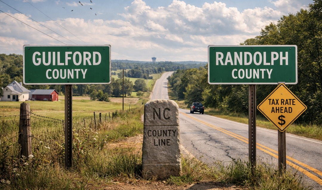
If you live near the county line in southern Guilford County, history suggests you might want to pay close attention to what the Guilford County Board of Commissioners hears next week.
At a special work session scheduled for Thursday, April 16, county staff will brief commissioners on a proposal to formally settle the boundary line between Guilford County and Randolph County – a process that, on paper, sounds straightforward but, in reality, has a long track record of turning into something much more complicated.
And the line with Randolph is a long one, which could have “shifted” a good deal over the years.
According to the county’s agenda for the work session, the board will consider “a resolution requesting the North Carolina Geodetic Survey to survey, mark and map the boundary between the Guilford County / Randolph County line.”
That request alone is enough to bring back memories of the county’s long-running and often bizarre saga with Alamance County – a dispute that dragged on for years, left homeowners in limbo and, at times, created a situation where people essentially chose which county they wanted to live in.
Asked this week whether the Randolph County issue could turn into a repeat of that drawn-out Alamance County drama, Chairman Skip Alston told the Rhino Times he’s still getting up to speed.
“I don’t know a lot about it yet; staff will report on it to us at the work session and then we’ll know more,” Alston said.
That answer might not provide much clarity, but, given the history of these disputes, it’s an honest one. Because if there’s one thing Guilford County officials have learned over the years, it’s that county lines aren’t nearly as clear cut as most people assume.
Over time, those lines can quite literally get lost.
When counties were originally established – in many cases in the 1800s – surveyors marked boundaries using physical landmarks, rudimentary tools and measurements that, by today’s standards, were often imprecise. Lines were supposed to be straight, but they didn’t always turn out that way.
Markers were placed in the ground to indicate boundaries, but those markers didn’t always stay put. They were moved, destroyed, buried or simply forgotten. Trees that once served as reference points were cut down. Streams changed course. Roads were rerouted.
Add in human nature – including a tendency for people to “assume” which county they were in or even decide they preferred one county over another – and you get the kind of confusion that has plagued Guilford County’s borders for decades.
In some cases, that confusion went far beyond simple uncertainty. It created real-world consequences.
People paid property taxes to one county when they were technically in another. Children attended schools in a county they didn’t officially reside in. Voters cast ballots in jurisdictions that may not have been theirs.
And, perhaps most importantly, emergency services, law enforcement jurisdiction and property records all became tangled in a bureaucratic mess.
Nowhere was that more evident than along the Guilford-Alamance County line.
That dispute stretched on for years and, at one point, took a turn that almost defied belief.
Rather than simply reestablishing the original straight line drawn when Alamance County was formed in 1849, officials considered – and, for a time, pursued – a “zigzag” boundary that would have allowed property owners near the line to choose which county they wanted to be in.
That approach might sound neighborly, but it quickly ran into a major problem: Everyone chose Alamance County to live in, which would have been a big hit to the Guilford County’s taxbase,
At the time, Alamance County had a significantly lower property tax rate than Guilford County – and that reality drove decision-making far more than geography.
In fact, when Guilford County commissioners briefly entertained the zigzag concept, 61 property owners opted to move into Alamance County and not a single one chose Guilford.
That outcome made it clear that allowing residents to pick their county wasn’t a workable solution – at least not from Guilford County’s perspective.
Ultimately, after years of back-and-forth, the two counties agreed to revert to the original “geodetic” line – a straight boundary confirmed using modern GPS surveying techniques and backed by the North Carolina General Assembly.
But even that resolution didn’t immediately solve everything.
Once the line was reestablished, county officials still had to go property by property to determine who belonged where – a painstaking process that involved tax records, school assignments and legal notifications.
As one county official put it at the time: “Now the real work begins.”
Settling a county line isn’t just about drawing a line on a map. It’s about untangling years – sometimes decades – of assumptions and habits.
Guilford County has seen similar issues pop up with other neighboring counties as well.
Following the Alamance County resolution, officials turned their attention to Rockingham County, where confusion over the boundary to the north had also created overlapping claims and uncertainty about where the line actually lay.
At one point, Guilford County Tax Director Ben Chavis summed up the situation bluntly: neither county was entirely sure where the line was.
That kind of ambiguity isn’t unusual, particularly in areas that have seen significant growth.
When land is largely rural – pastureland and woods – the exact location of a county line doesn’t matter much.
But when development arrives – homes, subdivisions, schools, businesses – the stakes get a lot higher. Suddenly, questions about taxes, zoning, school districts and emergency services become much more important.
And that’s when these long-dormant boundary issues tend to resurface.
One factor that has consistently influenced these disputes is the difference in property tax rates between counties.
Historically, Guilford County’s tax rate has been higher than its neighbors, including Alamance County.
At the time of the Alamance dispute, Guilford’s tax rate was roughly 73 cents per $100 of assessed value, compared to about 58 cents in Alamance County.
That gap made a tangible difference for homeowners – especially those with higher-value properties – and it’s one reason residents along disputed lines have often preferred to be located outside of Guilford County.
Currently, Guilford County has a property tax rate of 73.05 cents per $100 of assessed value, which is higher than surrounding counties. By comparison, Randolph County is 50 cents, Rockingham County is 58.01 cents, Davidson County 54 cents, and Forsyth County roughly 53.52 cents, while Stokes County is 62.50 cents. Alamance County, was at the center of past disputes, sits well below Guilford at 58 cents per $100.
Requesting a survey from the North Carolina Geodetic Survey is typically the first step in a formal process to establish a definitive boundary.
Once that survey is completed, the findings can be used to map the line precisely and resolve discrepancies between counties. But as past experience shows, the survey is just the beginning.
What follows can involve legislative action, inter-county agreements, detailed property reviews and, in some cases, pushback from residents who find themselves on the “wrong” side of the line.
It can also involve accommodations: In previous cases, counties have allowed students to finish their schooling in their current district even if their home was reassigned to another county.
Tax departments have worked together to smooth transitions and minimize disruption.
Still, there’s no getting around the fact that these decisions have real financial and personal impacts for some.
